 Ga naar de inhoud
TrackSnap – Accurate GPS data in urban canyons

The limitations of GPS in urban tram environments are not merely technical inconveniences—they are operational risks. However, these risks also present opportunities for innovation. TrackSnap emerges as a strategic enabler in this context, offering a suite of capabilities that transform unreliable GPS traces into actionable, track-accurate data.
Precision Recovery in Urban Canyons
By intelligently aligning GPS data to known tram track geometries, TrackSnap mitigates the effects of signal drift, multipath interference, and satellite occlusion. This ensures that vehicle positions remain consistent with physical infrastructure, even in the most challenging urban conditions.
Compatibility with Diverse Data Sources
TrackSnap is designed to work with both raw GPS inputs and enriched sensor data (e.g., IMU, odometry). For operators who lack access to onboard fusion systems, TrackSnap provides a robust fallback—enabling high-quality localization without hardware dependencies.
Enhanced Operational Intelligence
Accurate positioning unlocks reliable performance metrics: dwell times, headways, punctuality, and stop-level analytics. These insights support better planning, real-time dispatching, and predictive maintenance strategies.
Foundation for AI-Driven Optimization
Clean, track-snapped data is essential for training and deploying AI models in urban mobility. Whether for traffic flow prediction, anomaly detection, or automated control systems, TrackSnap provides the spatial integrity these models require.
Learn more about TrackSnap
To summarize: TrackSnap is not just a corrective tool—it is a catalyst for smarter, safer, and more efficient tram operations in the heart of the city.
The limitations of GPS in urban tram environments are not merely technical inconveniences—they are operational risks. However, these risks also present opportunities for innovation. TrackSnap emerges as a strategic enabler in this context, offering a suite of capabilities that transform unreliable GPS traces into actionable, track-accurate data.
Want to learn more?
Article: Why GPS Struggles in Cities
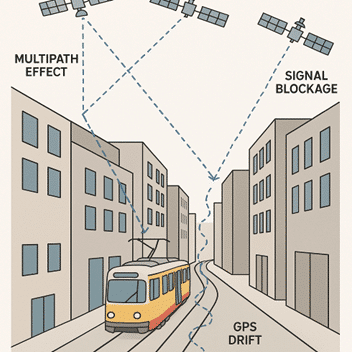
Global Navigation Satellite Systems (GNSS), including GPS, Galileo, GLONASS, and BeiDou rely on line-of-sight signals from satellites orbiting the Earth. In open landscapes, this system works well. But in dense urban areas, often referred to as urban canyons, the reliability and accuracy of GNSS positioning deteriorate significantly.
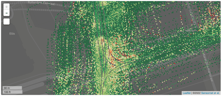
Urban canyoning refers to the phenomenon where tall buildings and narrow streets obstruct or reflect satellite signals, leading to degraded GPS accuracy. This is problematic in cities like Amsterdam, Düsseldorf, Budapest, or Prague, where trams operate in tightly built environments. The result is often a drifting GPS trace, which can misrepresent the actual position of a tram by several meters.
There are multiple contributing factors:
Signal Blockage
Tall buildings, overpasses, and tunnels obstruct the signal between satellites and receivers. This reduces the number of visible satellites, which weakens the geometric configuration needed for accurate triangulation. Fewer satellites equal lower accuracy.
Multipath Effects
Signals often bounce off reflective surfaces like glass, steel, or concrete before reaching the receiver. These reflected signals arrive later than direct ones, causing false distance measurements. This leads to positional drift, especially problematic for rail-bound systems like trams that require track-level precision.
Poor Satellite Geometry (Dilution of Precision)
Even when satellites are visible, their spatial distribution may be suboptimal. If satellites are clustered in one part of the sky (e.g., low elevation angles due to building blockage), the Dilution of Precision (DOP) increases, reducing the accuracy of the calculated position.
Interference and Noise
Urban environments are saturated with electromagnetic signals: mobile networks, Wi-Fi, Bluetooth, industrial equipment, and more. These can interfere with GNSS reception, especially if low-cost receivers are used in public transport systems.
Dynamic Environments
Cities are constantly changing: construction sites, temporary structures, and moving vehicles can alter signal paths unpredictably. This makes static GNSS models less effective and increases the need for adaptive correction techniques.

Impact of GPS Inaccuracies on Tram Operations
In dense urban environments, GPS inaccuracies can significantly disrupt tram operations. These errors are often caused by signal blockage, multipath effects, or poor satellite geometry. This can lead to position deviations of several meters. The consequences in a rail-based context are substantial.
Challenges for Predictive Maintenance
Location-tagged diagnostics (e.g., vibration anomalies or braking patterns) become unreliable if the spatial reference is off, reducing the effectiveness of condition-based maintenance.
These challenges highlight the need for enhanced positioning techniques—such as track snapping, sensor fusion, or 5G/UWB integration—to ensure reliable, high-resolution location data in complex urban environments.
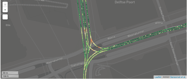
Track Snapping as a Solution
Track snapping is a technique that aligns raw GPS data to a known map of tram tracks
- Map-matching algorithms to correct GPS drift.
- Sensor fusion (e.g., GPS + Inertial Measurement Unit + Odometry) to improve robustness.
- Topology restrictions to ensure that positions remain on valid tram paths.
This approach is particularly effective in urban environments where GPS alone is unreliable. It enables:
- Accurate vehicle localization despite reduced GPS accuracy.
- Reliable data for fleet management and measurements.
- Enhanced input for AI-based traffic optimization.
Conclusion
Urban canyoning poses a real challenge for GPS-based tram tracking, but it is not insurmountable. With techniques like track snapping and sensor fusion, operators can achieve the precision needed for modern, data-driven transit systems. As cities become smarter, so must the tools we use to help navigate them.